The Portland, Oregon metropolitan area is fortunate to have multiple water sources to serve the region.
This diverse portfolio of water sources improves the region's resilience. Each source is unique and affected differently by emergencies, drought, and other vulnerabilities.
The region has five main surface water sources, groundwater, several smaller surface water sources, and aquifer storage and recovery (ASR). The five main water sources are the Bull Run Watershed, Clackamas River, groundwater, Trask and Tualatin Rivers, and the Willamette River. Smaller surface water sources include Gales Creek, Alder Creek, Brownell Springs, and South Fork Scappoose Creek and its tributaries (Gourlay Creek and Lazy Creek).
Regional Water Supplies Listed by Source:
Bull Run Watershed
Who it serves
The Bull Run Watershed is the City of Portland’s main water supply and serves over 950,000 residents in the region. It is a key source for the Water Bureau’s wholesale customers, which include City of Gresham, Lake Grove Water District, Rockwood Water People’s Utility District, Raleigh Water District, City of Sandy, City of Tualatin, Tualatin Valley Water District, and West Slope Water District.
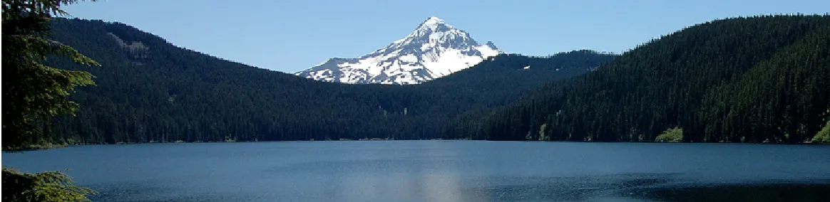
About the Watershed
Located 26 miles east of downtown Portland, OR in the Sandy River Basin, the protected Bull Run Watershed collects water from 135 inches of annual rainfall and some snowmelt that then flows into the Bull Run River and its tributaries. Most of the land within the 102 square-mile watershed is under federal ownership and the rest is owned by the City of Portland. The watershed is carefully managed to sustain and supply clean drinking water to a quarter of Oregon’s population.
The Water System
The Bull Run River drains into two reservoirs, where more than 9.9 billion gallons of water are stored during the summer. Bull Run River water is used for municipal and industrial uses and is also released to the lower river to improve habitat conditions for federal Endangered Species Act-listed fish. The water sent to Portland is currently unfiltered but is treated before it enters three conduits that transport it by gravity to where it is stored in a series of in-town reservoirs. The City of Portland is currently working on two treatment projects that will be completed in 2022 and 2027.
Find out how the Bull Run Watershed responds to high water demand or drought.
Clackamas River
Who it serves
The Clackamas River supplies high-quality drinking water to nearly 300,000 people in Clackamas and Washington Counties. Cities and water providers served by the Clackamas River include the cities of Estacada, Lake Oswego, and Tigard; South Fork Water Board which serves Oregon City and West Linn; the North Clackamas County Water Commission which serves the City of Gladstone, Sunrise Water Authority (cities of Happy Valley and Damascus), and Oak Lodge Water Services (Oak Grove, Jennings Lodge, and parts of Milwaukie and Gladstone); and Clackamas River Water (parts of unincorporated Clackamas County).
About the Watershed
The Clackamas River begins on the western slopes of the Cascade Range in Mount Hood National Forest. Forty-seven miles of the river are federally protected as part of the National Wild and Scenic Rivers System. The Clackamas River Watershed drains nearly 940 miles of forests, mountain meadows, agricultural land, suburban neighborhoods, and light industrial areas before meeting with the Willamette River. The Clackamas River is a highly-managed river with many uses including high quality drinking water, hydroelectric power, and outdoor recreation.
The Water System
The five main municipal surface water treatment facilities on the Clackamas River are managed by the City of Estacada, Clackamas River Water, the Lake Oswego-Tigard Partnership, the North Clackamas County Water Commission, and South Fork Water Board. In addition, there are three hydroelectric dams on the main stem of the Clackamas River with fish passage facilities and two dams on the Oak Grove Fork, managed by Portland General Electric. These dams do not serve as municipal water storage facilities. The water used by municipalities therefore is considered “run of the river” meaning all the water used is captured as it flows down the river.
Find out how the Clackamas River responds to high water demand or drought.
Groundwater
Who it serves
Groundwater is the primary water source for the cities of Milwaukie, Newberg, Scappoose, and Troutdale and is a secondary source for the City of Portland and its wholesale customers. The City of Gresham and Rockwood Water People’s Utility District jointly own and manage their own wells to supplement their supply from Bull Run Watershed.
About the Source
Groundwater is water found underground in the spaces between rocks, sand, and gravel. Groundwater usually comes from rain and snow melt that seeps into the ground or from nearby rivers and streams. The three primary aquifers in the region are the Blue Lake Aquifer, the Troutdale Sandstone Aquifer, and the Sand and Gravel Aquifer.
Water pumped from groundwater wells is treated and then pumped into a distribution system where it can then be delivered to customers.
There are also numerous aquifer storage and recovery (ASR) projects in the region. Aquifer storage and recovery is a way of storing drinking water underground, then pumping it out when it is needed. For example, during the winter and spring, the City of Beaverton and Tualatin Valley Water District inject treated drinking water from the Joint Water Commission (JWC) Water Treatment Plant into natural underground basalt formations (aquifers). Water is then pumped out through wells during the summer when customer demand increases.
The Water System
Portland Water Bureau’s Columbia South Shore Well Field is the second-largest developed water source in the state and the largest developed groundwater source. The well field is comprised of 26 wells ranging in depth from 55 to 657 feet and can produce up to 102 million gallons per day. It is located south of the Columbia River, east of Portland International Airport and west of Fairview and is served by three regional aquifers. Wells serving Rockwood Water People’s Utility District and the City of Gresham are located in Gresham and are part of the Cascade Well Field. Both well fields are covered by a wellhead protection program to prevent groundwater contamination. The City of Milwaukie taps the Troutdale Gravel Aquifer by means of seven wells that range from 250 to nearly 500 feet deep located around the City of Milwaukie. The City of Newberg owns and operates a wellfield where water is pumped from an underground aquifer located south of the Willamette River.
Find out how groundwater responds to high water demand or drought.
Tualatin and Trask Rivers
Who it serves
The Trask and Tualatin rivers provide high quality drinking water to 10 public water systems which serve over 470,000 customers in Washington County. The Joint Water Commission (JWC) manages a water treatment plant on the Tualatin River and serves all or portions of the Cities of Beaverton, Forest Grove, Hillsboro, and the Tualatin Valley Water District. The City of Cornelius purchases water from the City of Hillsboro.
About the Watershed
The Tualatin River watershed is in a 220-square-mile portion of the upper Tualatin River Basin that supplies water into the JWC water treatment plant intake. The 8.2 square mile Trask River watershed feeds the Barney Reservoir in the upper Trask River Basin. Water released from Barney Reservoir is diverted to the upper reaches of the Tualatin River. Ownership in the watershed includes private landowners and public agencies.
The Water System
The Tualatin River and its tributaries stretch almost 80 miles from the Tillamook State Forest in Washington County to the Willamette River near West Linn. The Trask/Tualatin River Basin serves members of the Joint Water Commission (JWC) and a small municipal supply with stored water from the municipally-owned Barney Reservoir and the reservoir formed by the Bureau of Reclamation-owned Scoggins Dam (also known as Hagg Lake) along with natural stream flow.
Find out how the Tualatin and Trask Rivers respond to high water demand or drought.
Willamette River
Who it Serves
The Willamette River currently supplies water to Wilsonville and Sherwood. Several water providers have water rights on the Willamette and its use is being expanded. To meet the needs of future generations, the City of Hillsboro is currently partnering with the Tualatin Valley Water District and the City of Beaverton to develop the Willamette River at Wilsonville as an additional water supply source for customers, by 2026.
About the Watershed
The Willamette River Basin is the largest watershed in Oregon with 13 major tributaries along its near 190-mile stretch which starts near the City of Eugene and ends at the confluence with the Columbia River in North Portland. This basin drains over 11,000 square miles of forest, farmland, and urban areas. It's bound by the Coast Range to the west and the Cascade Mountains to the east, comprising nearly 12% of Oregon's land. Snowpack, rain, and groundwater all contribute to the Willamette River's flow throughout the year.
The Water System
The U.S. Army Corps of Engineers operates 13 dams along its 13 tributaries, resulting in a highly regulated flow for flood control, fish habitat, recreational opportunities, and a variety of other municipal, agricultural, and industrial needs.
For municipal use, a large water intake facility and water treatment plant located in Wilsonville currently provides water for the Cities of Wilsonville and Sherwood. Tualatin Valley Water District (TVWD) and the Cities of Hillsboro and Beaverton are partnering to further develop the mid-Willamette River at Wilsonville as a future water supply source starting in 2026. The new treatment plant will deliver water through more than 30 miles of pipe to TVWD and Hillsboro.
Find out how the Willamette River responds to high water demand or drought.